I wanted to take advantage of the great weather that's hanging around after that early fall storm and spend another full day in the mountains. Unfortunately, I couldn't find anyone to join in the "fun" (on either side of the border) so solo it was! Though, admittedly, if I'd known I was going to have the route-finding issue I had, it probably would have been better to be with someone.
I really enjoyed the trails in the Manning Park area when
I was there in July and decided to head back, but this time going for a longer outing at lower elevations. The
Cascade Recreation Area seemed like a good option for a long loop.
Starting from the Cascade Rec. parking lot on Crowsnest, I took the Whatcom Trail over Punch Bowl Pass and down to Paradise Meadows, then the Dewdney trail to Hope Pass, Hope Pass Trail back to Crowsnest and then the highway to where I parked.
 |
| First view of Snass SW2 from the Whatcom Trail headed toward Punch Bowl Pass. |
Snow started around 5,100' going up to the pass, but was patchy and disappeared as the trail gets out of the trees and onto the open alpine area just below the pass.
 |
| Looking back south from just below the pass. Silvertip back right, Marmot in front, Rahm, Custer and Redoubt back center (I think). |
 |
| Looking north to Punch Bowl Lake and the Cascade Rec. Area from the pass. Snow was crunchy and icy and continued down past the lake for a bit. One track of footprints from a trip I saw on the ClubTread forum. The lake had ice on about half of it. Warburton Peak back left. |
 |
| Near Paradise Meadows on the Dewdney Trail. |
 |
| Not that my feet were dry before this, but still a dumb choice :) |
 |
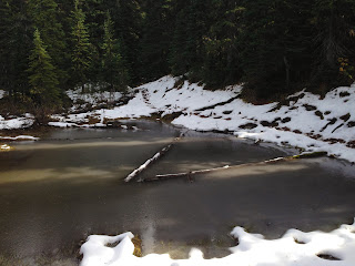
| Tulameen River crossing. |
 |
| Holding Creek crossing; ice cold and it'll soak you all the way up to your manpris! |
 |
| More nice meadows. |
 |
| Snow on Dewdney heading east toward the FS road. |
 |
| Slogging along the FS road going to the Hope Pass area. |
 |
| Looking southwest from the area around Kettle Mountain. |
Along most of the "ridge" of the FS road there is 6-12" of snow. The road is mostly compact snow-ice from trucks, but since it didn't appear that any hikers had been up here I couldn't find the shortcut turn off from Skaist down to the Hope Pass-Nicomen Lake trail junction. Instead I continued down the road to the Hope Pass Trail intersection, then had a snowy climb back up to Hope Pass. I didn't see any human/horse prints, so I guess no one has been up there for the last couple of weeks.
 |
| My lonely footprints from the FS road to Hope Pass-Nicomen junction. Trail was easy to follow, though. |
 |
| Hope Pass-Nicomen Lake trails junction. |
By this point I'd probably spent 6-8 miles in the snow and was looking forward to getting back on dirt.
 |
| Descending the Hope Pass Trail. |
 |
| Quite a bit of mud in the snow-to-dirt transition areas. |
Even though almost all of the trails I was on are stock trails, they really feel like backcountry singletrack (at least this time of year). In the 38 miles of trail (excluding Crowsnest) I covered yesterday I saw ONE PERSON: a guy with two horses at the Tulameen Ranger cabin, and that was it. Given the weather, that surprised me.
All the trails were in good shape too. Some blowdown on Whatcom and quite a few moderately-brushy areas on the middle portion of the Hope Pass Trail, but otherwise everything was really nice.
I had originally planned on taking the Skagit Bluffs Trail back to the parking area, but since the snow had slowed me down and I had to take the long way around Hope Pass I was much later than expected and chose Crowsnest as a quicker alternative. It's not the safer option, probably, but it was getting late.
Overall a good day.


