A number of recent Teanaway-area trail reports showing melted-out high country piqued my interest, and
Ethan was keen to join.
We took Stafford Creek up to Navaho Peak (7,223'), then the Standup Creek trail over to the SW ridge of Earl Peak and took the boot path to the summit (7,036'), exited via Bean/Beverly Creek trails and looped back on the forest service roads to the car.
No real issues getting to Navaho Peak, however expect light-to-moderate cross-country snow travel from west Stafford Creek all the way over the pass SE of Earl and down to the trail on the west side of Standup Creek (climbing to the pass is deep, soft snow on moderately-steep terrain). Trail to the summit of Earl is snow free, with some steep patches of snow remaining from the SW ridge of Earl maybe 400' vertical on the way down to Bean Creek.
 |
| Lower Stafford Creek trail |
 |
| Glacier Lily |
 |
| Setting moon above the ridge SW of point 6459' |
 |
| Meadows at 5600' on the way to Navaho Pass |
 |
| Stafford Creek basin, with Earl Peak and the pass to get there below-left of the moon |
 |
| Climbing to Navaho Pass |
 |
| Some snow low on the way to Navaho Peak |
 |
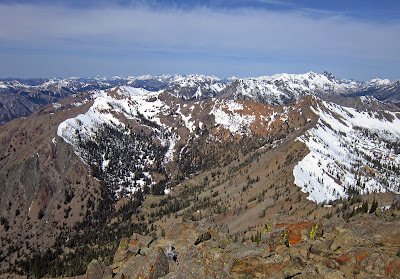
| It's a lot to take in from the summit of Navaho Peak at 7223'; with McClellan Peak, Little Annapurna, Dragontail, Colchuck, Argonaut, Sherpa, Stuart, Ingalls and Alpine Lakes Wilderness peaks beyond |
 |
| Rainier, Goat Rocks and Adams |
 |
| Descending Navaho on our way to Earl, upper left |
 |
| Climbing up to the pass SE of Earl |
 |
| Big cougar print |
 |
| Headed up Earl Peak |
|
 |
| Little tarn east of Earl Peak |
 |
| Stuart from the summit of Earl Peak |
 |
| Upper Bean Creek basin |
 |
| Earl Peak summit register |
 |
| Bean Creek |
 |
| Ethan beginning the fast descent down Bean Creek |


No comments:
Post a Comment